
An Open Framework for Architectural Caption and Attribute Data Enrichment via Street View Imagery
📄 Paper
OpenFACADES is an open-source framework designed to enrich building profiles with objective attributes and semantic descriptors by leveraging multimodal crowdsourced data and large vision-language models. It provides tools for integrating diverse datasets, automating building facade detection, and generating detailed annotations at scale.

1. Retrieving building image data:

2. Building image labeling and captioning using VLM:
-
Integrating multimodal crowdsourced data: acquire building data and street view imagery from crowdsourced platforms for selected areas, and conduct isovist analysis to integrate them.
-
Retrieving building image data: perform object detection to identify target buildings in panoramic images and reproject them back to a holistic perspective view, with image filtering functions to select high-quality building images.
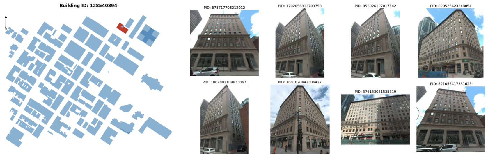


retrieving building image
- Establishing dataset and multimodal models: apply state-of-the-art multimodal large language models to annotate building images with multiple attributes, including building type, surface material, number of floors, and building age, and provide detailed descriptive captions.

(a) building attributes labeling

(b) image captioning
To install OpenFACADES, follow these steps:
- Clone the repository:
git clone https://github.com/seshing/OpenFACADES.git- Install the package and required dependencies:
conda create -n openfacades
conda activate openfacades

pip install -e OpenFACADES/.
pip install -r OpenFACADES/requirements.txt
Note: The package used pytorch and torchvision, you may need to install them separately. Please refer to the official website for installation instructions.
To acquire individual building images (Steps 1 & 2 above) for an area, you can simply run:
python OpenFACADES/run.py \
  --bbox=[left,bottom,right,top] \
  --api_key='YOUR_MAPILLARY_API_KEY'
Note: please check Mapillary has panoramic images available for the selected area.
Example bbox:
[8.552,47.372,8.554,47.376]: an area in Zurich, Switzerland;
[-81.382,28.540,-81.376,28.543]: an area in Orlando, the US;
[-70.660,-33.442,-70.655,-33.437]: an area in Santiago, Chile;
[-73.578,45.497,-73.569,45.502]: an area in Montreal, Canada;
[37.618,55.758,37.628,55.763]: an area in Moscow, Russia;
[25.273,54.684,25.283,54.687]: an area in Vilnius, Lithuania.
python OpenFACADES/run_local.py --source gsv --images "/path/to/panoramas" \
  --metadata "/path/to/metadata.csv"
Test on the GSV example:
python OpenFACADES/run_local.py --source gsv --images OpenFACADES/test/gsv/images \
  --metadata OpenFACADES/test/gsv/metadata.csv \
  --footprints OpenFACADES/test/gsv/footprint.geojson
Or test on the Baidu example (3 panoramas):
python OpenFACADES/run_local.py --source baidu --images OpenFACADES/test/baidu/images \
  --metadata OpenFACADES/test/baidu/metadata.csv \
--footprints OpenFACADES/test/baidu/footprint.geojsonSet MAPILLARY_API_KEY locally, then search by building ID:
python OpenFACADES/run_building.py --building-id way/123Returns up to 5 quality-filtered views, prioritising different sides, with a maximum
135° field of view. Numeric IDs default to OSM ways; relation/123 is also supported.
Results are saved to output/building_way_123/run_*/, with selected images listed in
02_img/individual_building_select.csv.
Output paths:
building footprint: output/01_data/footprint.geojson;
detected building images: output/02_img/individual_building;
building image ids after filtering: output/02_img/individual_building_select.csv.
To finetune InternVL models for building facade analysis and captioning, see our detailed training guide:
📖 Fine-tuning Guide — Instructions for training InternVL models on building data
🗂️ OpenFACADES Training Dataset — Training data on Hugging Face
[1] Liang, X., Yap, W., Biljecki, F., 2026. Heterogeneous graph neural networks for building attribute prediction from hierarchical urban features and cross-view imagery. ISPRS Journal of Photogrammetry and Remote Sensing 234, 185–204.
https://doi.org/10.1016/j.isprsjprs.2026.02.016
[2] Liang, X., Chang, J.H., Gao, S., Zhao, T. and Biljecki, F., 2024. Evaluating human perception of building exteriors using street view imagery. Building and Environment, 263, p.111875.
https://doi.org/10.1016/j.buildenv.2024.111875
[3] Liang, X., Cheng, S., Biljecki, F. (2025, June). Decoding Characteristics of Building Facades Using Street ViewImagery and Vision-Language Model. In 19th International Conference on Computational Urban Planning & Urban Management, CUPUM 2025. https://osf.io/abyqh/files/osfstorage/685400519a7097303ec89a95
[4] Lei, B., Liang, X. and Biljecki, F., 2024. Integrating human perception in 3D city models and urban digital twins. ISPRS Annals of the Photogrammetry, Remote Sensing and Spatial Information Sciences, 10, pp.211-218.
https://isprs-annals.copernicus.org/articles/X-4-W5-2024/211/2024/isprs-annals-X-4-W5-2024-211-2024.html
Please cite the following paper if you use OpenFACADES in a scientific publication:
Liang, X., Xie, J., Zhao, T., Stouffs, R., and Biljecki, F. (2025). OpenFACADES: An open framework for architectural caption and attribute data enrichment via street view imagery. ISPRS Journal of Photogrammetry and Remote Sensing, 230, 918–942. https://doi.org/10.1016/j.isprsjprs.2025.10.014
@article{liang2025openfacades,
        title = {OpenFACADES: An open framework for architectural caption and attribute data enrichment via street view imagery},
        author = {Liang, Xiucheng and Xie, Jinheng and Zhao, Tianhong and Stouffs, Rudi and Biljecki, Filip},
        year = 2025,
        journal = {ISPRS Journal of Photogrammetry and Remote Sensing},
        volume = {230},
        pages = {918--942},
        issn = {0924-2716},
        doi = {10.1016/j.isprsjprs.2025.10.014}
}We acknowledge the contributors of OpenStreetMap, Mapillary and other platforms for providing valuable open data resources and code that support street-level imagery research and applications. This project is also built with reference to the code of the following projects: InternVL, ZenSVI, GroundingDINO and Equirec2Perspec. Thanks for their awesome work!